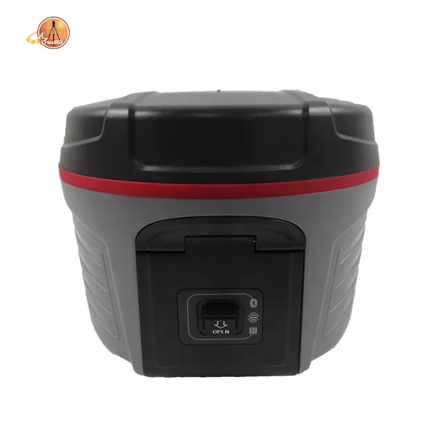
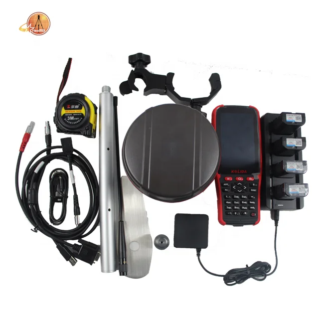
Popular Kolida K5 Plus+ Gps Gnss Rover and Base Station Receiver Mini Rtk of 220 Channels
Other recommendations for your business


Contact us
Quik Detail
| warranty | 1 year |
|---|---|
| customized support | None |
| place of origin | Shanghai, China |
| brand name | Kolida |
| Product name | Kolida K5 plus+ gps gnss rover and base station rtk of 220 channels |
| Application | Topographic Survey |
| Function | electronic bubbles |
| Static accuracy | Horizontal: 2.5mm+1ppm vertical 5mm+1ppm |
| Temperature Range | -30℃~+65℃ |
| Ingress protection | IP67 dustproof and waterproof |
| Brand | Kolida |
| Channels | 220 |
| Memory | Internal 8GB, support TF card |
| weight | 1.2kg with two batteries inside |
Product Detail
Popular Kolida K5 plus+ gps gnss rover and base station receiver mini rtk of 220 channels
PRODUCT DESCRIPTION

SUPER RTK is far ahead of ordinary GNSS receivers. Its mission area could be much bigger than others. It works where other receivers lose signals. It gives you total freedom: WebUI&SMS control, smart Apps, OTG field download. Even, it can transform into continuously operating Reference Station. Exceed the limitation, release your potential, SUPER RTK.
KEY FEATURES
 |
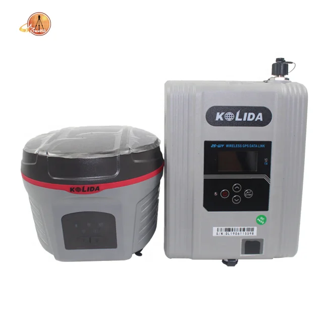
*Barrier-Free Measurement In difficult environment you may lost connection with base station or VRS network. You can choose from 3 creative work modes to continue surveying without interruption.(Reapter/Router/CSD) *Long Range Radio Link SDL400 built-in radio can send signal as far as 7km in urban area, 8km suburban. The maximum coverage is up to 200 sq.km, suitbale to have multiple rovers work simultaneously
|
|
*Anti-interference SDL400 built-in radio features anti-interference capability, so K5 plus+ can work close to power plant, transformer substation, mobile signal tower and other interference source. *The Best in Town To improve the performance in city survey, R&D team upgraded the network module from 3G to 4G. Under 4G mobile network, data transmission is faster and more stable. SUPER RTK is still compatible with 3G and 2G
|
 |
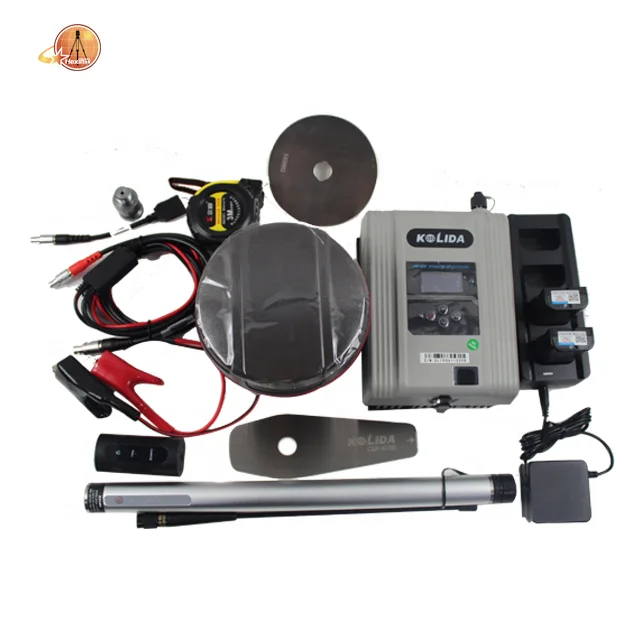
PRODUCT SHOW


PRODUT SPECIFICATION
| Satellites Signals Tracked Simultaneously | |
| Signal tracking | 220 channels |
| GPS: L1CA, L1C, L2C,L2E, L5 | |
| GLONASS: L1CA, L2CA, L2P, L1P, L3, | |
| BeiDou: B1, B2, B3; | |
|
GALILEO: GLOVE-A, GLOVE-B, E1, E5A,E5B |
|
| SBAS: L1CA, L5(Just for the statellites supporting L5) | |
| GNSS Features | Postioning output rate: 1Hz~50Hz Initialization time:<10s initialization reliability: >99.99% |
| Positioning precision | |
| Code differential GNSS positioning | Horizontal: ±0.25m+1ppm Vertical: ±0.5m+1ppm |
| SBAS positioning accuracy: typically<5m 3DRMS | |
| Static GNSS surveying | Horizontal: ±2.5mm+0.5ppm Vertical: ±5mm+0.5ppm |
| RTK surveying | Horizontal: ±8mm+1ppm Vertical: ±15mm+1ppm |
| Network RTK | Horizontal: ±8mm+0.5ppm Vertical: ±15mm+0.5ppm |
| Horizontal | 8mm+1ppm RMS |
| Vertical | 15mm+1ppm RMS |
| RTK Initialization time | 2-8s |
| User Interaction | |
| Operating Tine | Linux |
| Buttons | Double button operation |
| Indicator | Five indicators light |
| Web UI | Freely to configure and monitor the receiver by accessing to the Web server via WIFI or USB |
| Voice guide | Ivoice intellight voice technology provides status and voice guide. Supporting Chineses, Korean, Russian, Portuguese, Spanish, Turkish and user define |
| Secondary development | Providing secondary development kit |
| Hardware Performance | |
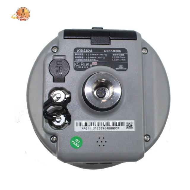
| Dimension(W*H) | 143mm×130mm |
| Weight | 1.43kg(two batteries included) |
| Material | Magnesium aluminum alloy shell |
| Operating | -45℃~+60℃ |
| Storage | -55℃~+85℃ |
| Humidity | 100% non-condensing |
| Waterproof/Dustproof | IP67 Standard, protected from short time immersion to depth of 1m |
| IP67 Standard, fully protected against blowing dust | |
| Shock&Vibration | withstand 2 meters pole drop onto the cement ground naturally |
| Power Supply | 9-25V DC, overvoltage protection |
| Battery | Rechargeble , Lithium-ion battery, 7.4V Dual batteries hot-swappable |
| Battery Life | Dual batteries>14h (static mode), >10h(internal UHF base mode), >12h(rover mode) |
| Communications | |
| I/O port | 5pin LEMO external power port+RS232, 7 PIN external USB(OTG)+Ethernet, 1 radio antenna interface, SIM card slot |
| Wireless modem | Built-in radio, 1w/2w/3w switchable, typically work range can be 8km. "Barrier-Free" measurement technology: Repeater/Router/CSD mode |
| Frequency Range | 410-470MHz |
| Communication Protocol | TrimTalk450S, TrimMark3, South(Kolida) |
| Cellular Mobile network | WCDMA/CDMA2000/TDD-LTE/FDD-LTE 4G network modem, downward compatible with 3G GPRS/ EDGE |
| Double Module Blue tooth | BLEBlue tooth 4.0standard, support for android, IOS cellphone connection. Blue tooth 2.1+EDR standard |
| NFC Communication | Realizing close range (shorter than 10cm) automatic pair between receiver and controller(controller equipped NFC wireless communication module needed) |
| External Devices | Optional external GPRS/EDGE dual-mode communication module, switchable; Allow to connet external WLAN card |
| WIFI | |
| Standard | 802.11b/g standard |
| WIFI Hotspot | The WIFI hotsopt allows smart mobile terminal to connect and access to the internal webserver to control and monitor receiver |
| WIFI data link | To work as the datalink that receiver is able to broadcast and receive differential data via WIFI |
| Data storage/Transmission | |
| Data Storage | 8GB SSD internal storage, support external USB storage(up to 32GB) and outomatical cycle storage, Changeable record interval, up to 50Hz raw data collection |
| Data Transmission | USB data transmission, support FTP/HTTP data download |
| Data Format | Differential data format: CMR+, CMR×, RTCM2.1, RTCM2.3, RTCM3.0, RTCM3.1, RTCM3.2. GPS output data format: NMEA0183, PJK plane coordinates, Binary code, Trimble GSOF. Network model support: VRS, FKP, MAC, Fully support NTRIP protocol |
| Inertial sensing system | |
| Tilt Survey | Built-in tilt compensator, correcting coordinates automatically according to the tilt direction and angle of the centering rod |
| Electronic Bubble | Controller software display electronic bubble, checking leveling status of the centering rod real time |
| Thermometer | Built-in thermomter sensors, adopting intelligent temperature control technology which can monitor and adjust the temperature of receiver in real time |
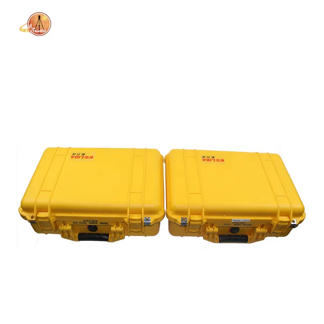
SHIPPING

PAYMENT

COMPANY INFORMETION
Company Profile
Shanghai Hexin Survey Instrument Co., LTD has 8 years' experience in geodetic surveying and cadastration surveying, we are a professional and leading enterprise in the surveying industry in MainlandChina. We specialize in the R&D and manufacturing and sales of all kinds of surveying products, including total station, electronic theodolite, electronic distance meter, automatic level, laser level, reflector prism, surveying accessory, GPS receiver, mapping software, etc.The marketing model advocated by us is not a simple sense of "selling products", instead, pre-sales service, services during operation and after-sales service are integrated in entire operating activities. It makes the customers feel that they purchased not only a commodity, but also a professional service.We welcome new and old customers from all walks of life to contact us for future business relationships and achieving mutual success!

RELATED PRODUCTS


FAQ
Q:How to turn off voice broadcast of receiver?
A:a. Enter the WEBUI, find the voice switch in the settings page and turn it off.
b. Controller Software→Device→Device Setting, turn off the “enable voice”, and click"ok"
Q:Can the base station and rover station be interchangeable?
A:The difference between the rover station and the base station is that the accessories are different, the function and hardware configuration are the same.You can use the controller to choose the working mode of the device and set it as the base station or rover station.
Q:What is CORS?
A:CORS is called a continuous operating reference station system. It can be understood as a bas e station that is erected at a fixed known point and works continuously for 24 hours and sends its own data to a specific
serverthrough the network. The use of CORS operation eliminates the need for a base station, and CORS is equivalent to a base station in a normal network operation.
![contact_us[1].jpg](http://sc01.alicdn.com/kf/Ha977df0d207b45ca8dbe0edb71b807d2a/220061674/Ha977df0d207b45ca8dbe0edb71b807d2a.jpg)